
17
Summer in the Dzungarian Alatau
No comments · Posted by Sergei Rzhevsky in Nature, Photos, Regions
The Dzungarian Alatau is a mountain range located on the border of the Almaty Region of Kazakhstan and the Xinjiang Uygur Autonomous Region of China, between the Ili River and Lake Alakol.
The mountains are named for the nearby desert. The length of this picturesque range is about 450 km, the width varies from 50 to 90 km, the height – up to 4,622 m (Semenov-Tian-Shansky Peak). The Dzungarian Alatau on Google Maps. Photos by: Grigory Bedenko.

Tags: Almaty oblast
1
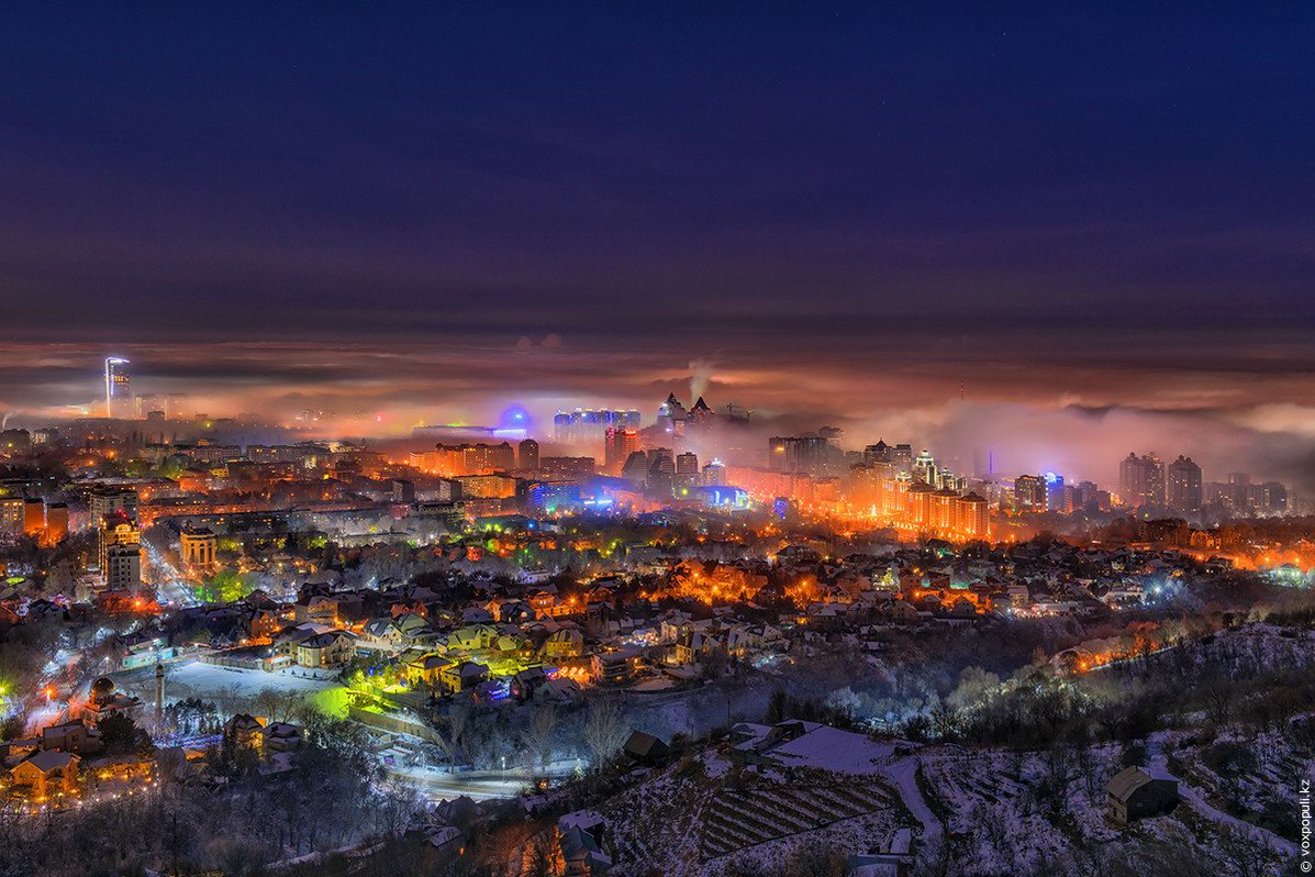
Almaty – the view from above
No comments · Posted by Sergei Rzhevsky in Cities, Photos, Travel
Almaty is the largest city in Kazakhstan with a population of about 1.8 million people. From 1991 to 1997, it was the capital of the country. The city is located in an intermountain depression at the foot of the mountains of Zailiysky Alatau in the extreme south-east of the republic.
The following photos of Almaty were taken at different times of the day and the year from the foothills surrounding the city and Almaty skyscrapers. The author of the photos published on voxpopuli.kz is the famous Kazakhstan photographer Maxim Zolotukhin.
Tags: Almaty city
Out with the old, in with the new!
May you be happy the whole year through!
Happy New Year 2019!
Picture: In the steppes of Kazakhstan by Ludmila Zhizhenko.
Tags: No tags
16
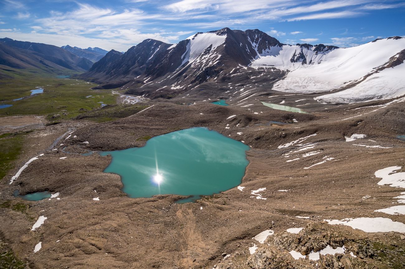
Pristine Beauty of the Dzungarian Alatau
No comments · Posted by Sergei Rzhevsky in Nature, Photos, Travel
The Dzungarian Alatau is a mountain range located in the northeast of the Almaty region of Kazakhstan, between the Ili River and Lake Alakol. The range extends from the west-southwest to east-northeast along the state border of Kazakhstan and China.
The length of the range is about 450 km, the width – 50-90 km. The main peaks of the Dzungarian Alatau rise above 4,000 m. The Dzungarian Alatau on Google Maps. Photos by: Grigory Bedenko.
Tags: Almaty oblast
29
One Windy Day on the Singing Barkhan
1 Comment · Posted by Sergei Rzhevsky in Nature, Regions, Travel
The Singing Barkhan is a large sand dune located in the territory of the Altyn Emel National Park in the Almaty region, 182 km northeast of Almaty. The length of it is up to 3 km, the height – about 150 m.
This natural monument is famous for the fact that in dry weather its sands emit sounds similar to an organ melody. The Singing Barkhan looks especially picturesque on a windy day. The Singing Barkhan on Google Maps. Photos by: Sergey Terekhov.

Tags: Almaty oblast
20
Things to Consider Before You Go for International Dating
1 Comment · Posted by Alex Smirnov in Entertainment
Finding a flirt or someone you can date over the internet is actually cool, fun, interesting and an exciting adventure, especially if you are single – and looking for someone to date.
However, not knowing these little-known secrets and mistakes (you need to avoid) can land you into trouble. Such that, you will even begin to hate the cool idea of international dating as a single when you end up being disappointed and broken due to ignorance.
So, what are these things you need to know then? They are:

Photo by: queendressast
Tags: No tags
7
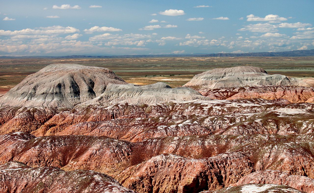
Amazing Landscapes of the Valley of Kiin Kirish
No comments · Posted by Sergei Rzhevsky in Nature, Regions, Travel
Kiin Kirish, an amazingly picturesque clay canyon, is a unique natural monument located 120 km southeast of the town of Kurshim in the East Kazakhstan region and covers an area of 300 hectares.
This place is also known as “The Town of Spirits”. Multicolored clays, eroded by water and wind, form vivid, bizarre landscapes here. The optimal time for a trip is 3-4 days. Kiin Kirish on Google Maps. Photos by: Sergey Silantjev.
Tags: East Kazakhstan oblast · Ust-Kamenogorsk city
4
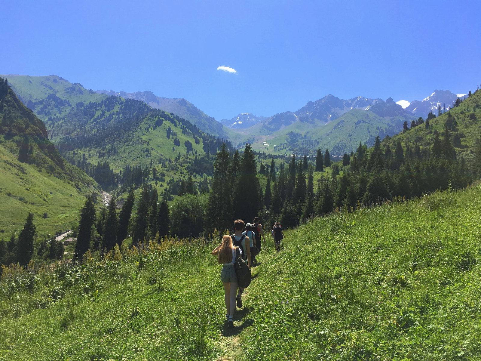
Hiking in Gorelnik Gorge in the vicinity of Almaty
No comments · Posted by Sergei Rzhevsky in Nature, Regions, Travel
Gorelnik Gorge is one of the most picturesque and easily accessible places located in the mountains near Almaty. It is very suitable for one-day mountain hikes.
To get there you should go to the Medeu ice rink, then climb to the dam, and go about 1.5 km further along the road towards Shymbulak, turn right, and behind the hunter’s house there is an entrance into the gorge. Gorelnik Gorge on Google Maps. Photos by: Ilya Gornostayev.
Tags: Almaty oblast
17
Sunken Forest of Lake Kaindy
No comments · Posted by Sergei Rzhevsky in Nature, Regions, Travel
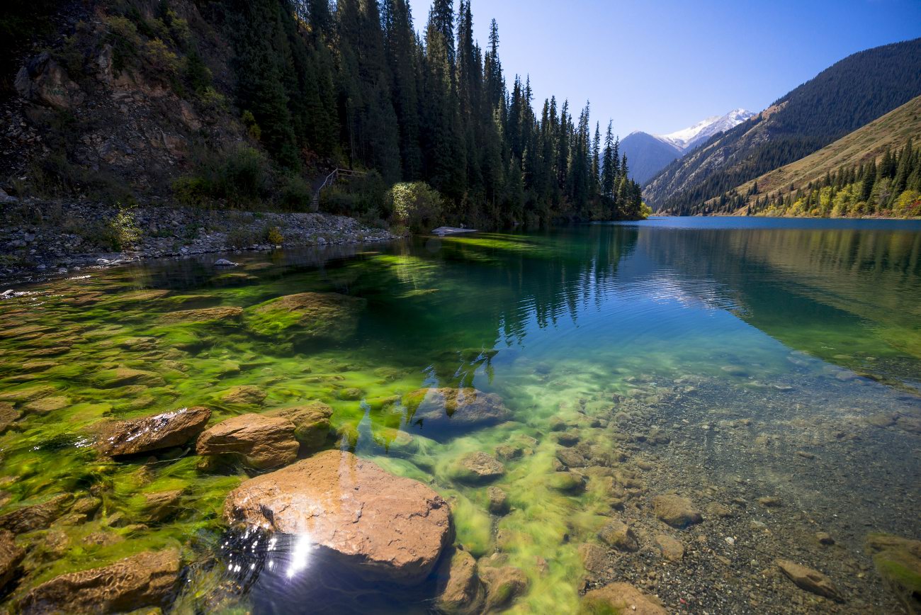
Kaindy is a 400 meters long lake located among coniferous forests at an altitude of 1,667 meters above sea level in the Almaty region of Kazakhstan, 284 km east of Almaty, a popular tourist destination.
Despite the low water temperature, Kaindy is very popular with diving enthusiasts. The main attraction of the lake is the remains of the spruce forest rising straight out of the water. Lake Kaindy on Google Maps. Photos by: Sergio.

Tags: Almaty oblast
9
Kolsay Lakes: a Paradise for Lovers
No comments · Posted by Alex Smirnov in Nature, Regions, Travel
In the northern Tien Shan, a cascade of three lakes, under the general name of the Kolsay lakes, is situated. Mountain ridges border a wonderful picture. Three high-altitude lakes are called the pearl of Kazakhstan.
They were formed as a result of the landslide descent to the bottom of the gorge when a fast-moving mountain river stopped its running at the dams that suddenly appeared on its way. This is an amazing place. So, if you find the one among Asian girls, then you can visit Kolsay lakes with her or even make a proposal there.
The first (Lower) Kolsay Lake
This lake is located not very far from the former capital of Kazakhstan. Stretching for 1.5 km in length, it is clamped in a narrow gorge. The lake is surrounded by high firs. They seem to have been specially planted here to preserve this paradise. The water in the lake is absolutely transparent and reflects the sky. Photos by: Grigory Bedenko.
Tags: No tags
