
The selection of postcards and photo reproductions below, of fairly decent quality, creates an image of Soviet Alma-Ata (currently Almaty) as a vibrant, modern city surrounded by snow-capped mountain peaks.
This city, which population reached one million in 1981, remains the cultural, economic, and financial capital of Kazakhstan. Since the late 1990s, it has experienced an investment and construction boom and has undergone significant changes. Therefore, photographs taken in the 1980s take on ever-increasing historical significance. Photos by visualhistory

Tags: Almaty city
8
The Pristine Nature of the Markakol Nature Reserve
No comments · Posted by Sergei Rzhevsky in Nature, Regions, Travel
In 1976, the Markakol State Nature Reserve was established on an area of 71,367 hectares to preserve and study the natural complexes of the southern Altai region and to study the ecology and fish population dynamics of the unique Lake Markakol.
Located in East Kazakhstan Oblast, the reserve protects natural complexes of meadows, steppes, larch taiga, mountain coniferous forests, subalpine and alpine meadows, and rocky tundra on the mountain slopes around Lake Markakol. (Lake Markakol on Google Maps). Photos by: Ilia Afanasieff.

Tags: East Kazakhstan oblast
7
The Unearthly Landscapes of Lake Tuzkol
No comments · Posted by Sergei Rzhevsky in Nature, Photos, Travel
Lake Tuzkol, located in the south-east of Almaty Oblast at an altitude of 1,959 m above sea level, is the saltiest mountain lake in Kazakhstan. The lake is quite large, 5.5 km long and up to 2 km wide in some places, but it’s shallow, only 3 meters deep. Its shores are low and gently sloping.
The salinity of the water varies depending on the season and can reach values comparable to the salinity of the water of the Dead Sea in Israel or the Great Salt Lake in the USA. Translated from the Kazakh language, “tuzkol” means “salt lake”.
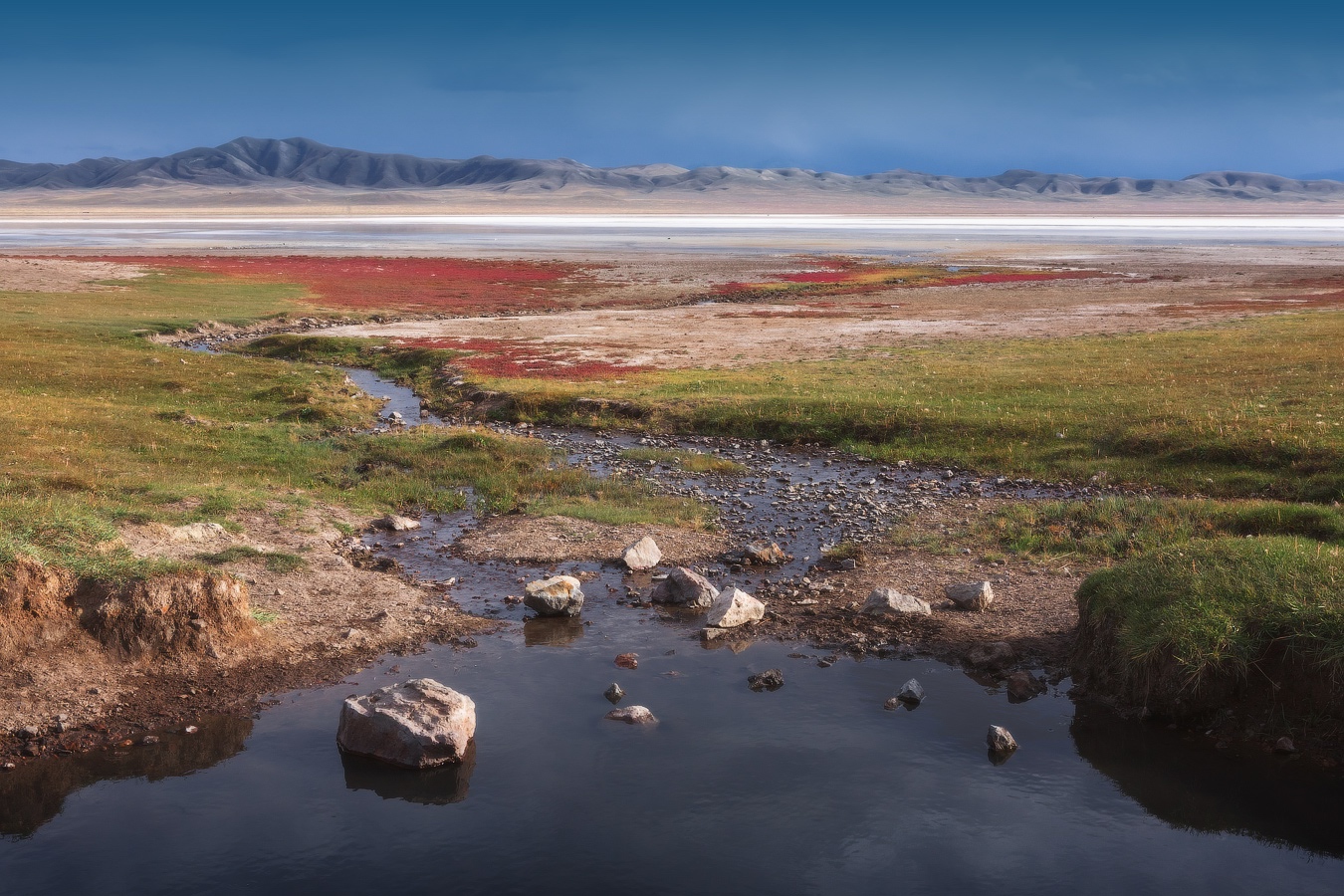
Tags: Almaty oblast · landscapes
3
Experience the Thrill of Winning with SPY4D
No comments · Posted by Sergei Rzhevsky in Entertainment
Have you ever wanted a place where every moment feels exciting, smooth, and full of happy energy, where you can enjoy your time and also feel proud of the rewarding results?
SPY4D gives you that kind of experience in a friendly and easy way. This platform is made for people who enjoy smooth online entertainment, clear options, and cheerful rewards that bring a smile.
SPY4D feels close to daily life, like something you can enjoy after work, during free time, or while relaxing at home with a cup of chai. Everything feels welcoming, positive, and easy to understand, so users can enjoy without any confusion.

Tags: No tags
18
The Largest Catholic Church in Kazakhstan
No comments · Posted by Alex Smirnov in Cities, Religion, Video
The Cathedral of Our Lady of Fatima (2004-2012), located in Karaganda, is the largest Catholic church in Kazakhstan and Central Asia. The cathedral’s model was the Cologne Cathedral in Germany. The design was developed by German architect Karl-Maria Ruf. The architect V.G. Sergeev adapted the design to Kazakhstan’s conditions.
On September 9, 2012, the cathedral was solemnly consecrated. Its brick walls are faced with shell rock, and a white marble statue of Our Lady of Fatima stands between the bell towers. Inside, the cathedral is decorated with tiled frescoes, stained glass windows, and a gilded altar with intricately carved wooden details. The cathedral houses the largest organ in Kazakhstan, which is frequently used in concert performances, often accompanied by the local symphony orchestra.
Tags: Karaganda city
12
WOLES4D: Built with Scalable and Future-Ready Technology
No comments · Posted by Sergei Rzhevsky in Entertainment, Technology
Are you curious about how modern digital platforms are built today so they stay smooth, fast, and ready for tomorrow at the same time? Many people use online systems daily and expect them to work well without thinking much about the technology behind them.
Still, the structure under the surface matters a lot. A platform built with scalable and future-ready technology feels stable today and remains useful as needs grow.
This article explains that idea in a simple way, using everyday language and clear logic, so anyone can understand how such technology supports steady growth and comfort over time.

Tags: No tags
11
Picturesque Cliffs of Boszhira
No comments · Posted by Sergei Rzhevsky in Nature, Regions, Travel
Boszhira, a mountain range consisting of numerous chalk cliffs, is located in the western part of the Ustyurt plateau on the Mangyshlak Peninsula in Mangystau Oblast.
Formerly a seabed, it covers a vast area and consists of rocks of various, unusual shapes formed by erosion. Exploring it would take more than a day. Boszhira on Google Maps. Photos by: Vladimir Mulder.
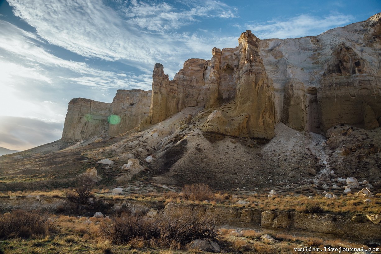
Tags: Aktau city · Mangystau oblast
31
KEY4D: Performance Driven Technology For Smooth Betting Use
No comments · Posted by Sergei Rzhevsky in Entertainment
Have you ever felt confused about how betting platforms work so fast without getting stuck or slow at the wrong time?
Many readers ask how modern betting systems manage speed, clarity, and steady flow while still keeping things simple for users. This article talks about performance driven technology behind KEY4D in an easy way, just like daily talks we do with friends. The focus stays on how technology supports smooth betting use, how systems work quietly in the background, and how users feel comfortable while using such platforms. Everything here is shared in a positive, clear, and honest manner using simple words that make sense to everyone.

Tags: No tags
5
Picturesque Landscapes of the Karkaraly Mountains
No comments · Posted by Sergei Rzhevsky in Nature, Regions, Travel
The Karkaraly Mountains are located in the eastern part of the Kazakh Uplands, 178 km southeast of Karaganda, 283 km northeast of Balkhash, 264 km southwest of Kurchatov, on the territory of the Karkaraly Nature Park, in the district of the same name in the east of Karaganda Oblast.
These mountains are a natural and historical heritage of Central Kazakhstan, one of the most picturesque and geologically interesting areas of the Kazakh Uplands. These mid-altitude granite ridges rise from the plains of Central Kazakhstan, forming a unique mountain forest oasis amidst the steppes. The Karkaraly Mountains on Google Maps. Photos by: Zekkadrb.
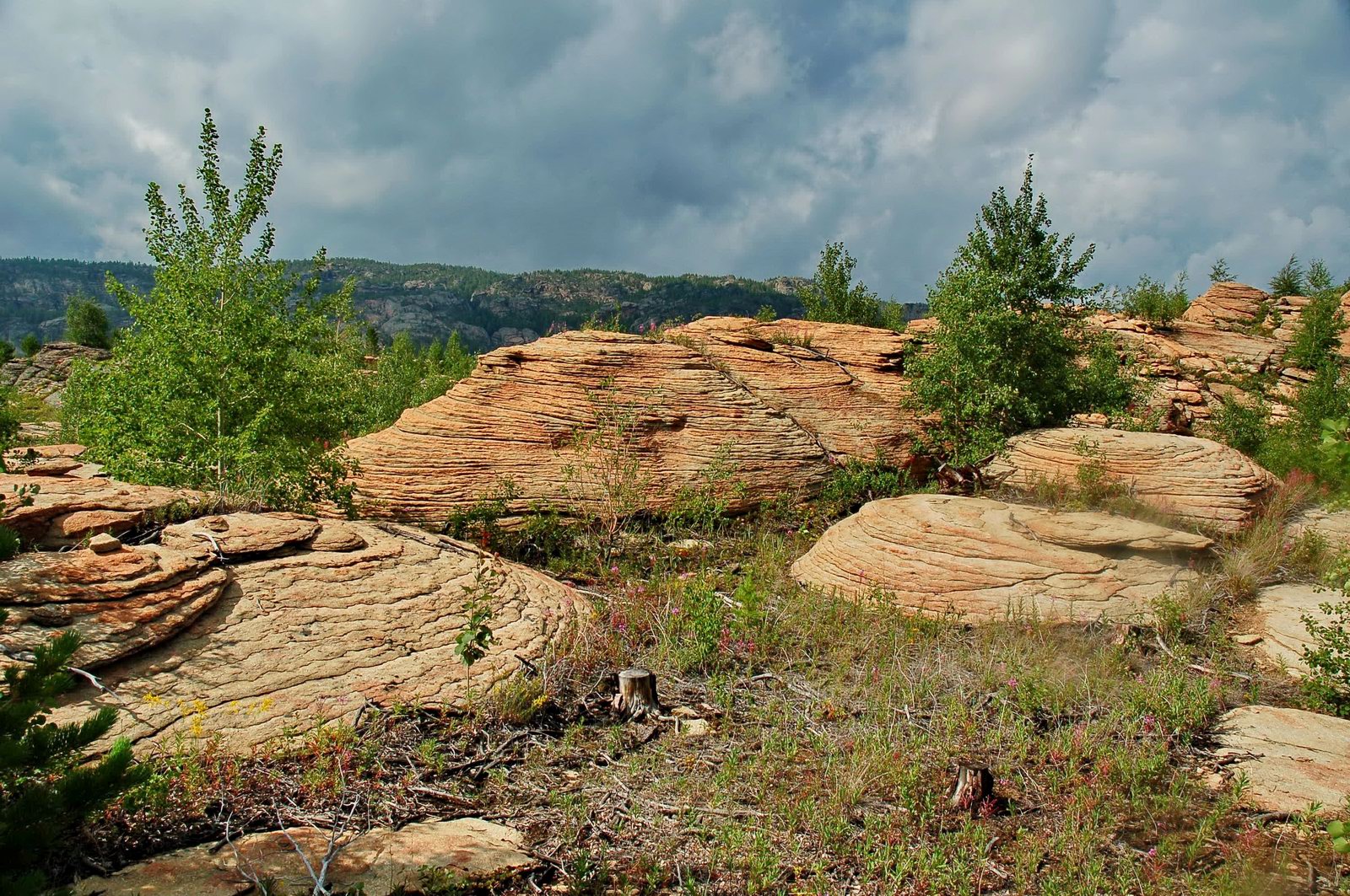
Tags: Karaganda oblast
3
The Stone Idols of Bayanaul National Park
No comments · Posted by Sergei Rzhevsky in Nature, Regions, Travel
Bayanaul State National Natural Park is a national park in Kazakhstan, located in the south of Pavlodar Oblast, approximately 100 km south of the city of Ekibastuz. It is one of the specially protected natural areas of Kazakhstan.
The park was founded in 1985, becoming the first national park in Kazakhstan. The reason for creating the park was the need to preserve and restore the natural flora and fauna of the Bayanaul mountain range. The total area of the park is 684.5 square kilometers. Bayanaul National Park on Google Maps. Photos by: Taimas Nurtaev.
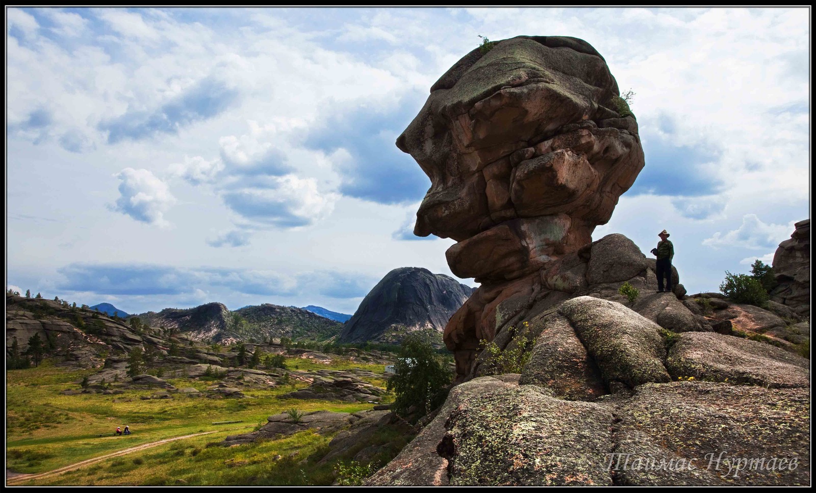
Tags: Ekibastuz city · landscapes · Pavlodar oblast
