
28
Online Slot Profit Maximization Methods for Gamers
No comments · Posted by Sergei Rzhevsky in Entertainment
Have you ever thought about ways to boost your online slot gains while still having a relaxed and entertaining experience? This guide provides positive insights on how to approach your gaming efforts with effective and practical steps. By focusing on strategies that are easy to apply, you can enjoy your sessions while keeping an eye on favorable outcomes.
Slots can be an enjoyable pastime for many, and the tips shared here are intended to help players make the most of their time. There are plenty of reliable methods that can lead to uplifting results when approached with care and positivity. This article is crafted in a casual style for easy reading and includes organized sections to keep information clear.

Tags: No tags
15
Giant Boulders on the Shore of Lake Okun’ki
No comments · Posted by Sergei Rzhevsky in Nature, Regions, Travel
Lake Dubygalinskoe (also known as Lake Okun’ki) is located in Ulansky district of East Kazakhstan Oblast, at the foot of the northern slopes of Mount Dubygaly. This lake and the surrounding rocks are like an oasis in the middle of the endless Kazakh steppe. It is about 70 km from Oskemen (former Ust-Kamenogorsk) and 140 km from Semey.
Besides the fact that it is a great place for fishing, the lake attracts travelers for its amazing giant boulders picturesquely scattered along the shore. Lake Okun’ki on Google Maps. Photos by Alexey Maznicin.
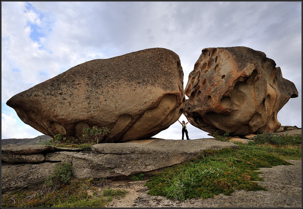
Tags: East Kazakhstan oblast · landscapes
10
Magnificent Landscapes of the Northern Tian Shan
No comments · Posted by Sergei Rzhevsky in Nature, Photos, Regions
The Tian Shan is a mountain system located in Central Asia in the territory of five countries: Kyrgyzstan, Kazakhstan, China (Xinjiang Uygur Autonomous Region), Tajikistan, and Uzbekistan. It is one of the highest mountain systems in the world with more than thirty peaks over 6,000 meters high.
Let’s look at the landscapes of the northern part of the Tien Shan located in Kazakhstan, near Almaty. The mountains of the Northern Tian Shan are the most visited in Kazakhstan. Photos by: Grigory Bedenko.
Big Almaty Lake located at an altitude of 2,511 meters above sea level.
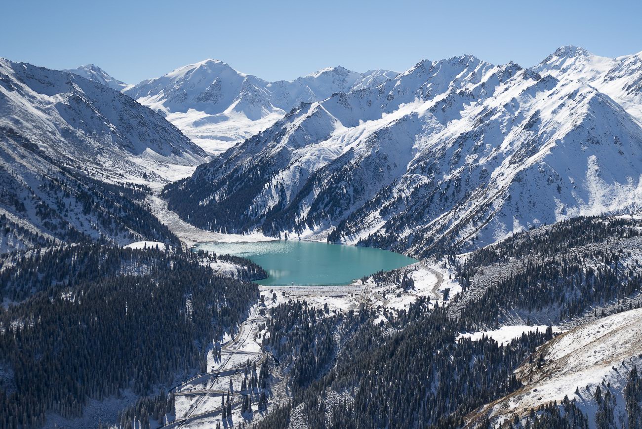
fly over the Northern Tian Shan
Tags: Almaty oblast
13
Colorful Landscapes of the Aktau Mountains
No comments · Posted by Sergei Rzhevsky in Nature, Regions, Travel
The chalk mountains of Aktau (literally “white mountains”), located about 260 km northeast of Almaty, is a unique natural monument that is part of the Altyn Emel National Park.
These multi-colored hills formed from bluish-gray sandstone and red clay, interspersed with yellow and pink cornelian, jasper, and white quartz, look like a layer cake. The height of the geological deposits reaches hundreds of meters. The Aktau Mountains on Google Maps. Photos by: Sergey Terekhov.
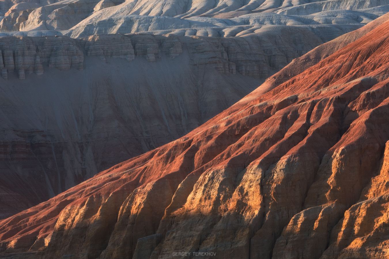
Tags: Almaty oblast
3
How to Master PG Soft’s Unique Game Mechanics on PGBET
No comments · Posted by Sergei Rzhevsky in Entertainment
PG Soft has taken the online slot gaming world by storm, offering captivating games with innovative mechanics that keep players coming back for more. Whether you’re new to PG Soft’s games or a seasoned player on PGBET, understanding and mastering these mechanics can significantly boost your success. In this guide, we’ll take a detailed look at how to master the unique game mechanics of some of PG Soft’s most popular titles, including Mahjong Ways, Lucky Neko, Wild Bandito, Treasures of Aztec, Caishen Wins, The Great Icescape, Ways of the Qilin, and Cocktail Nights.

Tags: No tags
1
Amazing Landscapes of Southern Kazakhstan
No comments · Posted by Sergei Rzhevsky in Nature, Regions, Travel
Southern Kazakhstan is the most densely populated part of the country. Here the largest cities of Kazakhstan, Almaty and Shymkent, are located.
The landscapes of Southern Kazakhstan are surprisingly diverse and represent a combination of arid, rather cold (in winter) and hot (in summer) sparsely populated steppes and deserts, snow-capped mountains, and densely populated foothills. Photos by: Dmitry Balakirev.
Famous boundless steppes of Kazakhstan – one of the symbols of the country.
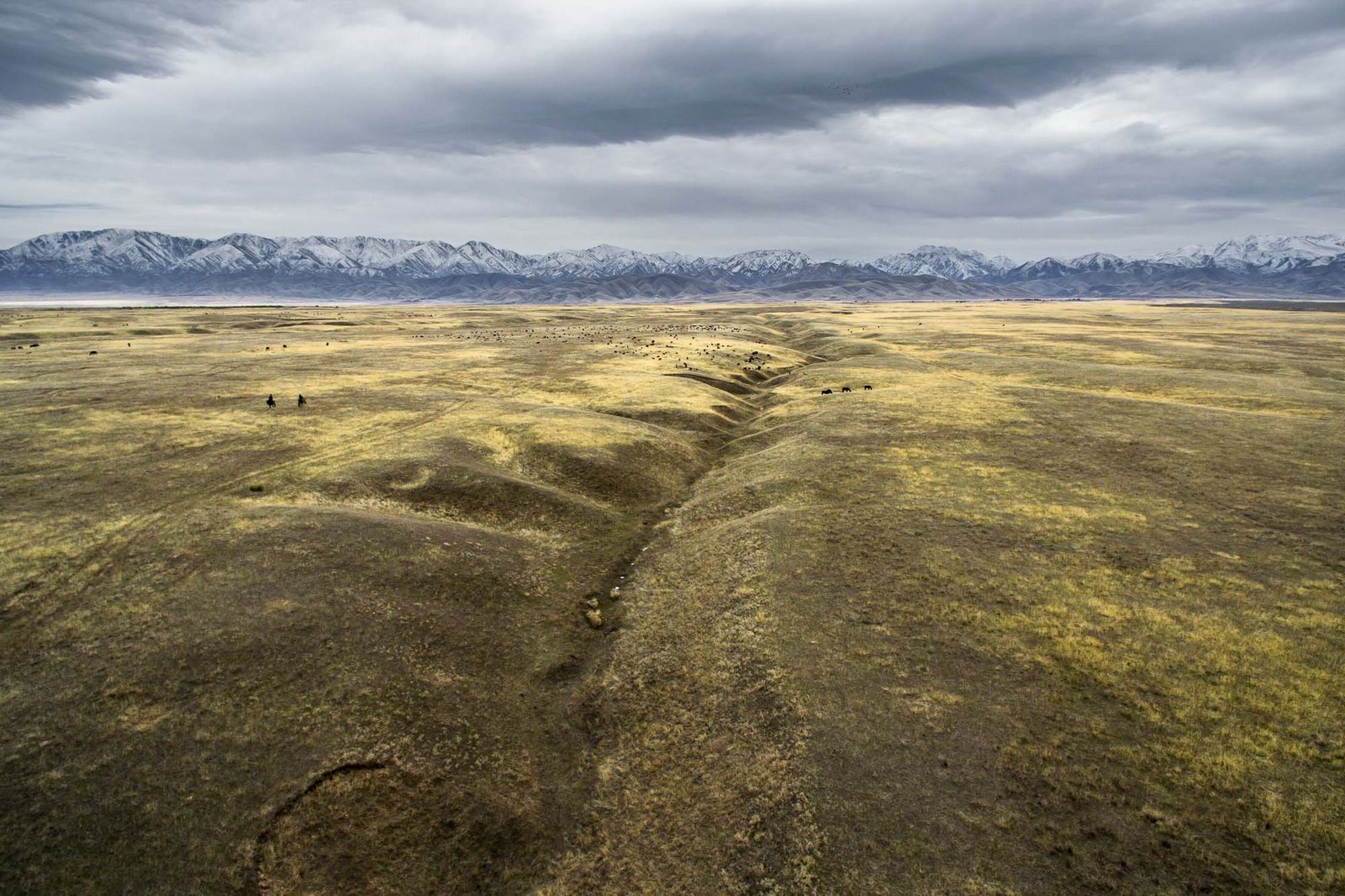
Tags: Almaty oblast · South Kazakhstan oblast
28
How to Play Like a Pro: Tips for Dominating the Competition
No comments · Posted by Sergei Rzhevsky in Entertainment
For online slot players in Indonesia, mastering the art of slot gaming requires more than just luck. While slots are often seen as games of chance, professional players know that there are strategies that can increase your chances of success and help you dominate the competition. Whether you’re new to the world of online slots or a seasoned player looking to improve your game, this guide will provide you with pro-level tips to elevate your gameplay and give you the competitive edge. Ready to play like a pro? Let’s dive into the strategies that will take your slot experience to the next level.

Tags: No tags
13
The Valley of Stone Balls on Mangyshlak Peninsula
No comments · Posted by Sergei Rzhevsky in Nature, Regions, Travel
Mangyshlak Peninsula is located on the eastern coast of the Caspian Sea in Kazakhstan. Mangystau Oblast is located on its territory.
One of the natural attractions of the peninsula is the Torysh Tract, which is located about 105 km north of the city of Aktau on the western end of the Western Karatau Ridge, 17 km east of the village of Tauchik.
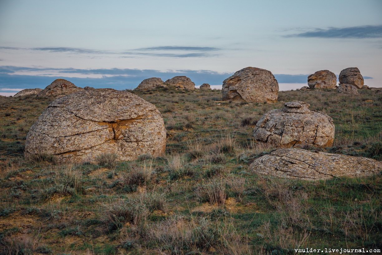
picturesque geological formations
Tags: Aktau city · Mangystau oblast
30
The Ultimate Guide to Pragmatic Play’s Best Games
No comments · Posted by Sergei Rzhevsky in Entertainment
Pragmatic Play has become a household name among online slots enthusiasts, especially for players in Indonesia who seek excitement and big wins. The game developer is known for its impressive portfolio of slots that cater to a wide range of preferences, from simple classic designs to feature-rich modern games. If you’re a current player or considering diving into the world of online slots, this guide will introduce you to some of Pragmatic Play’s best games, each offering a unique gaming experience.

Image by Dinh Quan from Pixabay
Tags: No tags
5
8 Best National Parks to Explore Worldwide
No comments · Posted by Sergei Rzhevsky in Nature, Travel
Exploring national parks worldwide offers a unique opportunity to experience some of nature’s most breathtaking landscapes and diverse ecosystems. From the dramatic fjords of New Zealand to the vast savannas of Tanzania, these protected areas are celebrated for their stunning beauty, rich biodiversity, and outdoor adventure opportunities.
Each park provides a distinct glimpse into the natural world, whether it’s through witnessing the annual wildebeest migration in the Serengeti or hiking the rugged trails of Torres del Paine. Whether you seek thrilling wildlife encounters, serene natural beauty, or challenging hikes, these national parks offer unforgettable experiences that highlight the wonders of our planet and inspire a deeper appreciation for the environment.
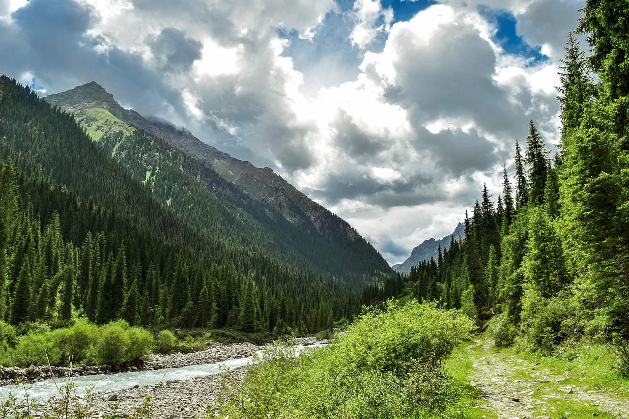
Image by trejlerfilms from Pixabay
Tags: No tags
