
CAT | Regions
31
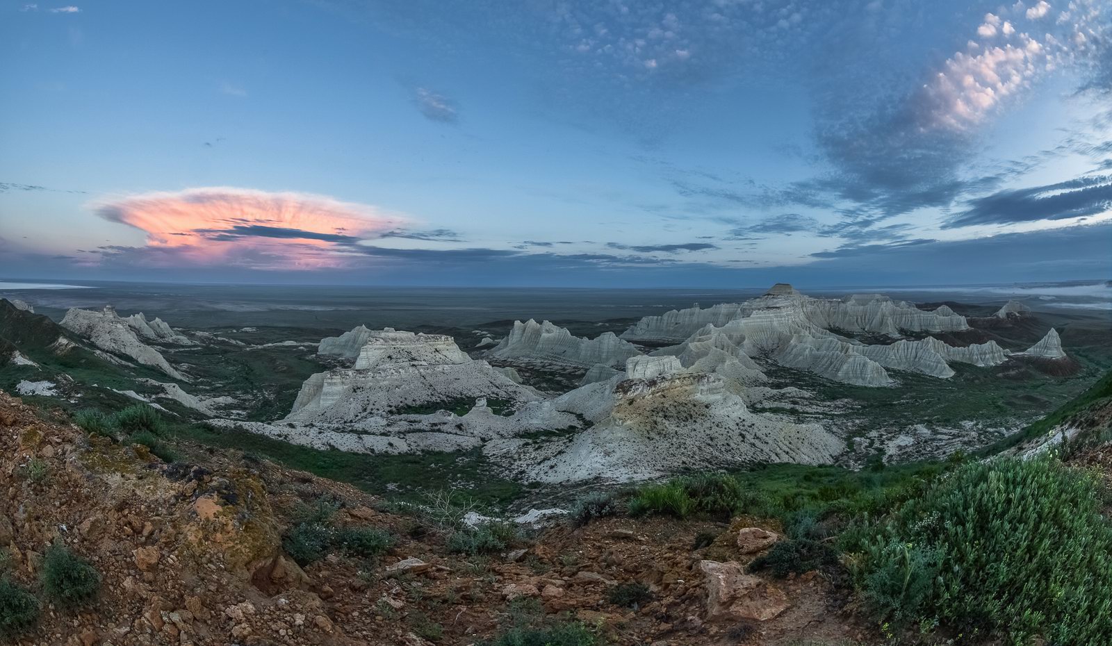
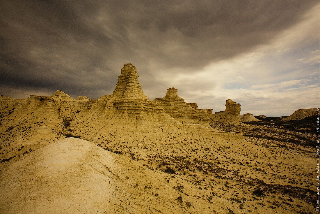
Morning on Aktolagay Plateau
No comments · Posted by Sergei Rzhevsky in Nature, Regions, Travel
Morning on the plateau of Aktolagay – a snow-white mountain range located in the very west of Aktobe Oblast, about 250 km east of Atyrau. This is a picturesque wasteland with no paved roads, houses, trees, and even drinking water – the realm of the wind where sometimes you can meet horses and camels.
Wind and water, flowing abundantly down the mountain range during heavy rains, turned the plateau into an amazing world of chalk figures. Aktolagay Plateau on Google Maps. Photos by: Aleksandr Manzhosov.

Tags: Aktobe oblast
23
Bizarre Chalk Cliffs of Akkergeshen Plateau
No comments · Posted by Sergei Rzhevsky in Nature, Regions, Travel
Akkergeshen Plateau, known for its bizarre weathered snow-white cliffs, is located about 56 km northeast of the town of Kulsary in the Atyrau region.
Shark teeth, remains of dinosaurs, prints of ancient plants and animals on stones – all this can still be found on this chalky plateau. Akkergeshen Plateau on Google Maps. Photos by: Denis Frantsouzov.
Tags: Atyrau oblast
4
Beautiful Landscapes of Lake Balkhash
No comments · Posted by Sergei Rzhevsky in Nature, Regions, Travel
Balkhash is a drainless semi-freshwater lake located in the south-east of Kazakhstan in the Almaty, Zhambyl and Karaganda regions. This is the second largest perennial salt lake (after the Caspian Sea) and the 14th in the list of the largest lakes in the world.
The uniqueness of Balkhash is that it is divided into two parts by a narrow strait with different chemical characteristics of the water – in the western part it is almost fresh, and in the eastern part it is brackish. Lake Balkhash on Google Maps. Photos by: Andrey Zhuravlev.

the largest inner lake of Kazakhstan
Tags: Almaty oblast · Karaganda oblast · Zhambyl oblast
11
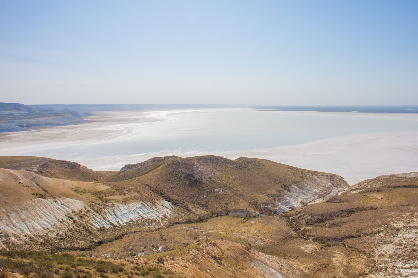
Snow-white landscapes of Sor Tuzbair
No comments · Posted by Sergei Rzhevsky in Nature, Regions, Travel
Sor Tuzbair is a solonchak (salt marsh) located in the Mangystau region in the south-west of Kazakhstan. Almost the entire territory of this region is covered with saline and deserts, water sources are absent.
This is a picturesque area combining three colors: white – salt, limestone, clouds; blue – the sky; yellow-brown – the color of the soil, which emphasizes the whiteness of salt. Sor Tuzbair is a natural combination of deserts, hills and cliffs. People come here to explore the salt marsh and conquer rocky peaks. Sor Tuzbair on Google Maps. Photos by: Natalya Kozlovskaya.
Tags: Mangystau oblast
29
One Windy Day on the Singing Barkhan
1 Comment · Posted by Sergei Rzhevsky in Nature, Regions, Travel
The Singing Barkhan is a large sand dune located in the territory of the Altyn Emel National Park in the Almaty region, 182 km northeast of Almaty. The length of it is up to 3 km, the height – about 150 m.
This natural monument is famous for the fact that in dry weather its sands emit sounds similar to an organ melody. The Singing Barkhan looks especially picturesque on a windy day. The Singing Barkhan on Google Maps. Photos by: Sergey Terekhov.

Tags: Almaty oblast
7
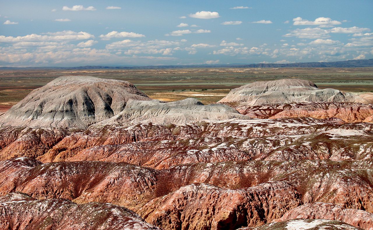
Amazing Landscapes of the Valley of Kiin Kirish
No comments · Posted by Sergei Rzhevsky in Nature, Regions, Travel
Kiin Kirish, an amazingly picturesque clay canyon, is a unique natural monument located 120 km southeast of the town of Kurshim in the East Kazakhstan region and covers an area of 300 hectares.
This place is also known as “The Town of Spirits”. Multicolored clays, eroded by water and wind, form vivid, bizarre landscapes here. The optimal time for a trip is 3-4 days. Kiin Kirish on Google Maps. Photos by: Sergey Silantjev.
Tags: East Kazakhstan oblast · Ust-Kamenogorsk city
4
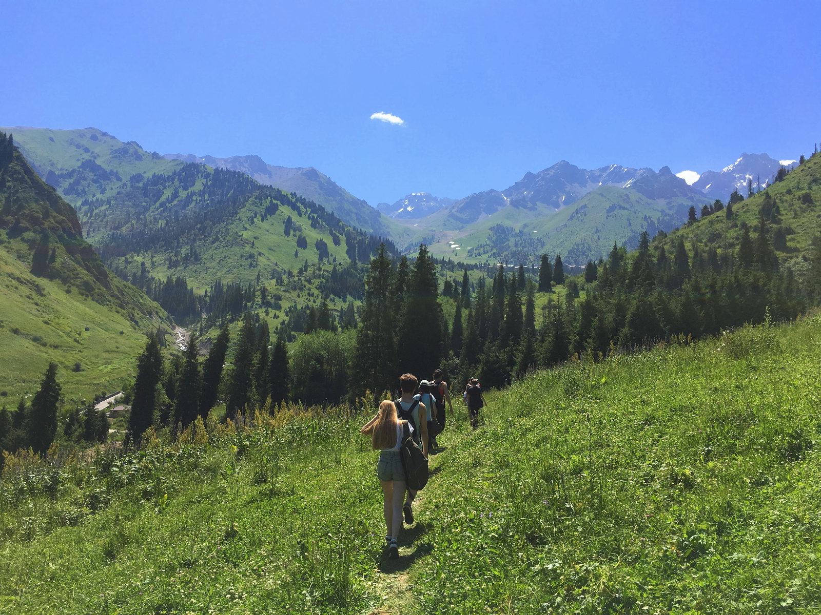
Hiking in Gorelnik Gorge in the vicinity of Almaty
No comments · Posted by Sergei Rzhevsky in Nature, Regions, Travel
Gorelnik Gorge is one of the most picturesque and easily accessible places located in the mountains near Almaty. It is very suitable for one-day mountain hikes.
To get there you should go to the Medeu ice rink, then climb to the dam, and go about 1.5 km further along the road towards Shymbulak, turn right, and behind the hunter’s house there is an entrance into the gorge. Gorelnik Gorge on Google Maps. Photos by: Ilya Gornostayev.
Tags: Almaty oblast
17
Sunken Forest of Lake Kaindy
No comments · Posted by Sergei Rzhevsky in Nature, Regions, Travel
Kaindy is a 400 meters long lake located among coniferous forests at an altitude of 1,667 meters above sea level in the Almaty region of Kazakhstan, 284 km east of Almaty, a popular tourist destination.
Despite the low water temperature, Kaindy is very popular with diving enthusiasts. The main attraction of the lake is the remains of the spruce forest rising straight out of the water. Lake Kaindy on Google Maps. Photos by: Sergio.

Tags: Almaty oblast
9
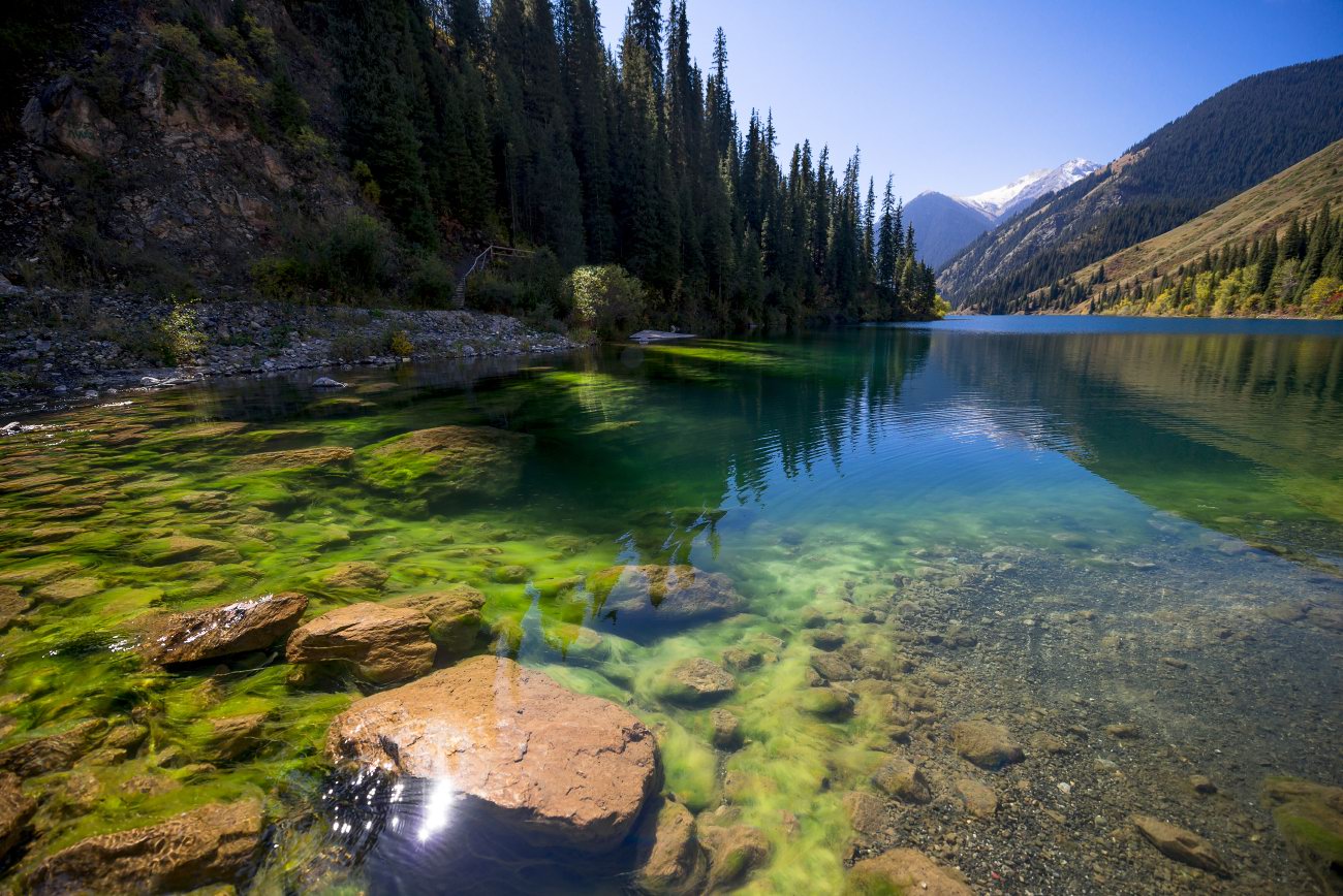
Kolsay Lakes: a Paradise for Lovers
No comments · Posted by Alex Smirnov in Nature, Regions, Travel
In the northern Tien Shan, a cascade of three lakes, under the general name of the Kolsay lakes, is situated. Mountain ridges border a wonderful picture. Three high-altitude lakes are called the pearl of Kazakhstan.
They were formed as a result of the landslide descent to the bottom of the gorge when a fast-moving mountain river stopped its running at the dams that suddenly appeared on its way. This is an amazing place. So, if you find the one among Asian girls, then you can visit Kolsay lakes with her or even make a proposal there.
The first (Lower) Kolsay Lake
This lake is located not very far from the former capital of Kazakhstan. Stretching for 1.5 km in length, it is clamped in a narrow gorge. The lake is surrounded by high firs. They seem to have been specially planted here to preserve this paradise. The water in the lake is absolutely transparent and reflects the sky. Photos by: Grigory Bedenko.
Tags: No tags
1
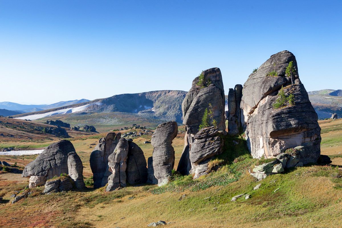
Rock Formations of the Western-Altai Reserve
No comments · Posted by Sergei Rzhevsky in Nature, Regions
The Western-Altai State Nature Reserve was established with the goal of comprehensive protection of the Altai mountain system in 1992. It covers an area of about 56 thousand hectares at the northeastern border of the East Kazakhstan region, 60 km east of the city of Ridder.
This territory has a complex geological history. Here you can see picturesque rock formations – geological monuments of the distant past. The Western-Altai Reserve on Google Maps. Photos by: Ilya Afanasyev.
Tags: East Kazakhstan oblast · Ridder city
